
Northwest Florida on Alert Ahead of Possible Hurricane Isaias Impact Noroeste de Florida bajo alerta ante posible impacto del huracán Isaías
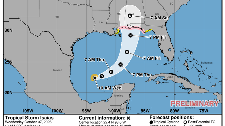
Florida is preparing for the possible arrival of Isaias, which could make landfall on Saturday as a Category 2 hurricane or potentially become even stronger.
Northwest Florida is on alert as Tropical Storm Isaias approaches and could strike the northern Gulf Coast on Saturday as a powerful hurricane, according to the National Hurricane Center (NHC).
Parts of the Florida Panhandle are currently under hurricane or tropical storm watches. Authorities are also warning of a possible storm surge of up to five feet along portions of the coast.
In response to the threat, Florida Governor Ron DeSantis declared a state of emergency Tuesday night for 25 counties across northern Florida.
“Floridians should take this time to prepare their disaster plans and make sure their hurricane supply kits are fully stocked,” DeSantis said in a statement.
Isaias Continues to Strengthen
According to the National Hurricane Center’s 11 a.m. update, Isaias had strengthened slightly compared with earlier in the morning, and that trend is expected to continue as the storm moves over large areas of warm water.
These conditions could allow Isaias to become the first hurricane of the season as early as Wednesday night.
The latest forecast indicates that maximum sustained winds could reach 110 miles per hour at landfall, placing the storm near the upper limit of Category 2 intensity.
Forecasters have not ruled out rapid intensification under these conditions. However, an area of strong wind shear near the coast could weaken the storm somewhat before it reaches land.
Meteorologists also warned that Isaias could expand in size shortly before landfall, potentially spreading strong winds, heavy rain, and storm surge impacts across a wider area.
Uncertainty Over Where the Storm Will Make Landfall
There is still significant uncertainty surrounding the exact path of Isaias.
Traditional weather models, which are based on physical atmospheric processes, are shifting the storm’s track farther west, while newer artificial intelligence-based models are projecting a more easterly path.
For now, the National Hurricane Center is taking a middle-ground approach. However, its 11 a.m. update once again shifted the forecast track slightly eastward, bringing the possibility of stronger impacts closer to Florida.
“It should be noted that many of the stronger solutions tend to be located on the eastern half of the guidance envelope and are faster, which makes a variety of watches necessary at this time,” the National Hurricane Center said.
Authorities continue to urge residents across northern Florida to review their emergency plans, secure their homes, and closely monitor official updates as Isaias approaches the Gulf of Mexico.
Florida se prepara para la posible llegada de Isaías, que podría tocar tierra el sábado como un huracán de categoría 2 o incluso alcanzar una intensidad mayor.
El noroeste de Florida se encuentra bajo alerta ante el avance de la tormenta tropical Isaías, que podría impactar la costa norte del Golfo de México durante el sábado convertida en un poderoso huracán, según informó el Centro Nacional de Huracanes (NHC).
Parte del Panhandle de Florida está actualmente bajo vigilancia de huracán o de tormenta tropical. Las autoridades también advierten sobre una posible marejada ciclónica de hasta cinco pies en sectores de la costa.
Ante la amenaza, el gobernador de Florida, Ron DeSantis, declaró el martes por la noche el estado de emergencia en 25 condados del norte del estado.
“Los floridanos deben aprovechar este momento para preparar sus planes ante desastres y asegurarse de tener abastecido su kit de suministros para huracanes”, señaló DeSantis en un comunicado.
Isaías continúa fortaleciéndose
De acuerdo con la actualización de las 11 de la mañana del Centro Nacional de Huracanes, Isaías mostró un ligero fortalecimiento y se espera que esa tendencia continúe mientras el sistema avanza sobre amplias zonas de aguas cálidas.
Estas condiciones podrían permitir que Isaías se convierta en el primer huracán de la temporada tan pronto como la noche del miércoles.
El pronóstico indica que los vientos máximos sostenidos podrían alcanzar las 110 millas por hora al momento de tocar tierra, una intensidad situada en el límite superior de un huracán de categoría 2.
Sin embargo, los especialistas no descartan un fortalecimiento más rápido. Al mismo tiempo, una zona de fuerte cizalladura del viento cerca de la costa podría provocar cierto debilitamiento antes de que el ciclón llegue a tierra.
Los meteorólogos también advierten que Isaías podría aumentar de tamaño durante las horas previas a su llegada, ampliando la zona expuesta a fuertes vientos, lluvias y marejada ciclónica.
Incertidumbre sobre el punto de impacto
La trayectoria definitiva de Isaías todavía presenta un alto grado de incertidumbre.
Los modelos meteorológicos tradicionales, basados en principios físicos, están proyectando una trayectoria más hacia el oeste, mientras que algunos modelos desarrollados con inteligencia artificial sitúan el sistema más hacia el este.
Por el momento, el Centro Nacional de Huracanes mantiene una trayectoria intermedia. No obstante, su actualización de las 11 de la mañana desplazó nuevamente el recorrido previsto ligeramente hacia el este, acercando la posibilidad de impactos significativos sobre Florida.
“Muchas de las soluciones más intensas tienden a ubicarse en la mitad oriental de las proyecciones y a ser más rápidas, lo que hace necesarias diversas alertas en este momento”, indicó el organismo.
Las autoridades continúan recomendando a los residentes del norte de Florida revisar sus planes de emergencia, asegurar sus viviendas y mantenerse atentos a las próximas actualizaciones oficiales mientras Isaías se aproxima al Golfo de México.